Home > Europe > United Kingdom > England > London > Boroughs > Hounslow
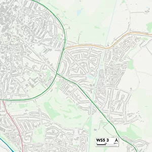
Hounslow TW14 9 Map

![]()
Wall Art and Photo Gifts from Map Marketing
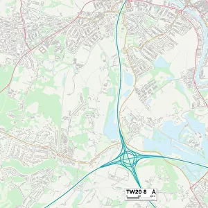
Hounslow TW14 9 Map
Postcode Sector Map of Hounslow TW14 9
Media ID 19982312
Ambleside Drive Andover Close Ashmead Road Buckingham Avenue Burns Avenue Chandlers Close Churchill Close Clive Road Derwent Close Edward Road Ennerdale Close Fern Grove Gladstone Avenue Glebelands Road Grasmere Close Hatton Road Hounslow Jubilee Way Kendal Close Kingston Avenue Link Road Longford Avenue Manor Place Marriott Close Myrtle Avenue Nelson Close New Road Nursery Close Orchard Avenue Park Way Richmond Avenue Rosslyn Avenue Ruskin Avenue Shaftesbury Avenue Shakespeare Avenue Sheffield Road Shrewsbury Road Snowdon Road Southern Avenue Staines Road Swansea Road Tennyson Close The Gardens Trevithick Close Walker Close Waterloo Close Wellington Road Welwyn Avenue Westminster Close Windermere Close
FEATURES IN THESE COLLECTIONS
> Europe
> United Kingdom
> England
> London
> Boroughs
> Hounslow
> Europe
> United Kingdom
> England
> London
> Sights
> Richmond Park
> Europe
> United Kingdom
> England
> Northumberland
> Related Images
> Europe
> United Kingdom
> Wales
> West Glamorgan
> Swansea
> Map Marketing
> Postcode Sector Maps
> TW - Twickenham
> Maps and Charts
> Related Images
> Popular Themes
> Waterloo Station
MADE IN THE USA
Safe Shipping with 30 Day Money Back Guarantee
FREE PERSONALISATION*
We are proud to offer a range of customisation features including Personalised Captions, Color Filters and Picture Zoom Tools
SECURE PAYMENTS
We happily accept a wide range of payment options so you can pay for the things you need in the way that is most convenient for you
* Options may vary by product and licensing agreement. Zoomed Pictures can be adjusted in the Cart.