Home > Europe > United Kingdom > England > Manchester > Ardwick
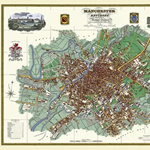
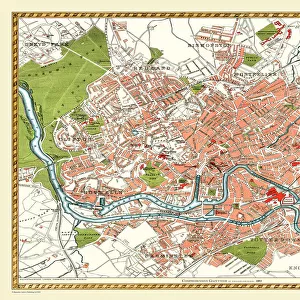
Old Map of Manchester 1851 by John Tallis

![]()
Wall Art and Photo Gifts from MapSeeker
Old Map of Manchester 1851 by John Tallis
This John Tallis Victorian map, 1851, of Manchester in Lancashire covers the districts of Salford, Manchester, Ardwick, Chorlton and Hulme. Railways are now established, however the plan beautifully illustrates the complex shipping canals snaking their way through Manchester and Salford. The illustrations finishing the plan are of the Royal Infirmary, Branch of the Bank of England, Royal Institution, Town Hall, Post Office, Free Library and Collegiate Church
Welcome to the Mapseeker Image library and enter an historic gateway to one of the largest on-line collections of Historic Maps, Nostalgic Views, Vista's and Panorama's from a World gone by.
Media ID 20347640
Historic Map John Tallis John Tallis Map Old Town Plan Tallis Map Manchester Manchester City
FEATURES IN THESE COLLECTIONS
> Arts
> Artists
> T
> John Tallis
> Europe
> United Kingdom
> England
> Lancashire
> Banks
> Europe
> United Kingdom
> England
> Lancashire
> Church
> Europe
> United Kingdom
> England
> Lancashire
> Related Images
> Europe
> United Kingdom
> England
> Manchester
> Ardwick
> Europe
> United Kingdom
> England
> Manchester
> Manchester
> Europe
> United Kingdom
> England
> Manchester
> Salford
> Europe
> United Kingdom
> England
> Maps
> Europe
> United Kingdom
> England
> Railways
> Europe
> United Kingdom
> England
> Salford
> MapSeeker
> British Town And City Plans
> English & Welsh PORTFOLIO
EDITORS COMMENTS
This stunning print of the "Old Map of Manchester 1851" by John Tallis takes us back in time to Victorian-era Manchester. The intricate details and craftsmanship of this map beautifully capture the essence of a city on the cusp of industrial revolution. The map covers various districts including Salford, Manchester, Ardwick, Chorlton, and Hulme. While railways have begun to establish their presence in the area, it is the network of shipping canals that truly stands out. These snaking waterways were vital for trade and transportation during that era. What makes this map even more captivating are the illustrations adorning its borders. They showcase prominent landmarks such as the Royal Infirmary, Branch of the Bank of England, Royal Institution, Town Hall, Post Office, Free Library, and Collegiate Church. Each illustration provides a glimpse into important institutions that shaped Manchester's history. As we admire this historic map today, we can't help but marvel at how much has changed over time while appreciating what remains constant – a city steeped in rich heritage and progress. This print serves as a reminder of Manchester's vibrant past and its continuous evolution into one of Britain's most dynamic cities.
MADE IN THE USA
Safe Shipping with 30 Day Money Back Guarantee
FREE PERSONALISATION*
We are proud to offer a range of customisation features including Personalised Captions, Color Filters and Picture Zoom Tools
SECURE PAYMENTS
We happily accept a wide range of payment options so you can pay for the things you need in the way that is most convenient for you
* Options may vary by product and licensing agreement. Zoomed Pictures can be adjusted in the Cart.