Home > Arts > Artists > H > Jodocus Hondius
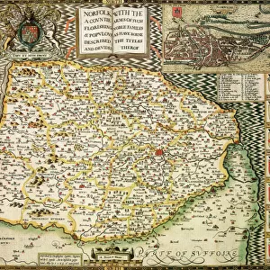
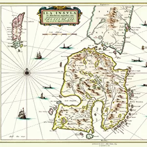
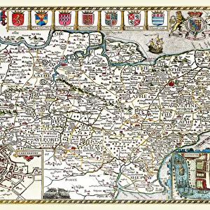
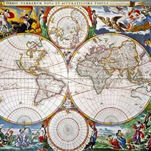
Old County Map of Norfolk 1648 by Johan Blaeu from the Atlas Novus

![]()
Wall Art and Photo Gifts from MapSeeker
Old County Map of Norfolk 1648 by Johan Blaeu from the Atlas Novus
This detailed and most attractive reproduction map of Norfolk has been carefully art worked from a scan of an antique original. The famous firm of Dutch cartographers and publishers was established in the late 16th century by Willem Janszoon Blaeu in Amsterdam. Blaeu was a maker of globes and scientific instruments and purchased some of his early map plates from Jodocus Hondius. From this small beginning was to emerge one of the largest and most prolific map publishing houses of the seventeenth century
Welcome to the Mapseeker Image library and enter an historic gateway to one of the largest on-line collections of Historic Maps, Nostalgic Views, Vista's and Panorama's from a World gone by.
Media ID 20347689
Blaeu Blaeu Family Blaue Map County Map County Map Of England English County Map Historic Map Johan Blaeu Johan Blaeu Map Old Blaue Map Old County Map Old English County Map
FEATURES IN THESE COLLECTIONS
> Arts
> Artists
> B
> Willem Blaeu
> Arts
> Artists
> H
> Jodocus Hondius
> Arts
> Photorealistic artworks
> Detailed art pieces
> Masterful detailing in art
> Europe
> United Kingdom
> England
> Maps
> Europe
> United Kingdom
> England
> Norfolk
> Related Images
> Maps and Charts
> Early Maps
> Maps and Charts
> Related Images
> Maps and Charts
> Willem Janszoon Blaeu
> MapSeeker
> Maps from the British Isles
> England and Counties PORTFOLIO
EDITORS COMMENTS
This beautifully crafted print showcases an exquisite reproduction of the "Old County Map of Norfolk 1648" by Johan Blaeu from the Atlas Novus. Carefully art worked from a scan of an antique original, this detailed and captivating map takes us back in time to explore the historical landscape of Norfolk. The renowned Dutch cartographer and publisher, Willem Janszoon Blaeu, established his firm in Amsterdam during the late 16th century. Initially known for his globes and scientific instruments, Blaeu's passion for cartography led him to acquire map plates from Jodocus Hondius. From these humble beginnings emerged one of the largest and most prolific map publishing houses of the seventeenth century. With its intricate details and artistic flair, this old English county map offers a fascinating glimpse into Norfolk's past. Its rich history unfolds as we trace ancient roads, discover charming villages nestled amidst lush countryside, and navigate meandering rivers that have shaped this region over centuries. As we delve into this historic masterpiece by Johan Blaeu, we are transported to a time when maps were not just navigational tools but works of art themselves. This exceptional piece captures both our imagination and curiosity about Norfolk's heritage. Whether you are an avid collector or simply appreciate historical artifacts, this stunning reproduction is sure to captivate anyone with an interest in English county maps or those seeking a unique piece that celebrates Norfolk's intriguing past.
MADE IN THE USA
Safe Shipping with 30 Day Money Back Guarantee
FREE PERSONALISATION*
We are proud to offer a range of customisation features including Personalised Captions, Color Filters and Picture Zoom Tools
SECURE PAYMENTS
We happily accept a wide range of payment options so you can pay for the things you need in the way that is most convenient for you
* Options may vary by product and licensing agreement. Zoomed Pictures can be adjusted in the Cart.