Home > Europe > United Kingdom > England > Sussex > Patching
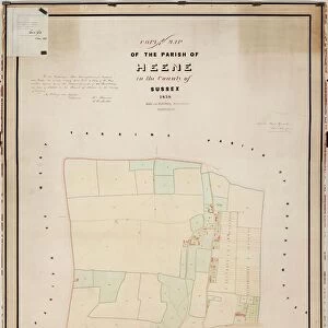
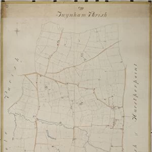
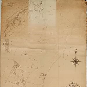
Broadwater Tithe Map, 1848

![]()
Wall Art and Photo Gifts from West Sussex County Council
Broadwater Tithe Map, 1848
By Messrs. Hide & Patching, Surveyors, Worthing. Standidge & Co. litho. 36 Old Jewry, London. 26.6 in. to 1 m. Original map size 112in. × 60in.
Tithe Award Map Collection
West Sussex Record Office Ref No: TD/W21
West Sussex County Council Record Office contains a fascinating history of the county of West Sussex, England
Media ID 7915666
© West Sussex County Council - All Rights Reserved
FEATURES IN THESE COLLECTIONS
> Europe
> United Kingdom
> England
> Sussex
> Broadwater
> Europe
> United Kingdom
> England
> Sussex
> Patching
> Europe
> United Kingdom
> England
> Sussex
> Related Images
> Europe
> United Kingdom
> England
> Sussex
> West Worthing
> Europe
> United Kingdom
> England
> Sussex
> Worth
> Europe
> United Kingdom
> England
> Sussex
> Worthing
> Europe
> United Kingdom
> England
> West Sussex
> Related Images
> Europe
> United Kingdom
> England
> West Sussex
> Worthing
> Maps and Charts
> Early Maps
> Maps and Charts
> Related Images
> West Sussex County Council
> West Sussex Record Office
> Tithe Award Maps, 1808-1859
EDITORS COMMENTS
This print showcases the Broadwater Tithe Map, a remarkable piece of historical mapping from 1848. Created by the esteemed surveyors Messrs. Hide & Patching in Worthing and skillfully lithographed by Standidge & Co. in London, this map is an invaluable artifact that offers a glimpse into the past. Measuring an impressive 112 inches by 60 inches, this meticulously detailed map provides a comprehensive overview of the Broadwater area during the mid-19th century. Every inch of land is carefully depicted with precision and accuracy, allowing us to visualize how this region appeared over 170 years ago. The West Sussex Record Office has diligently preserved this significant piece of history, assigning it the reference number TD/W21 within their extensive Tithe Award Map Collection. This collection serves as a treasure trove for historians and researchers alike who seek to understand and explore our rich heritage. It's important to note that while this print highlights the craftsmanship behind creating such maps, it does not promote or endorse any commercial use. Instead, its purpose lies in appreciating and celebrating our shared history through visual representation. As we gaze upon this extraordinary image, let us reflect on how far we have come since those early days captured within its intricate lines and symbols. May it inspire curiosity about our roots and encourage further exploration into West Sussex's fascinating past.
MADE IN THE USA
Safe Shipping with 30 Day Money Back Guarantee
FREE PERSONALISATION*
We are proud to offer a range of customisation features including Personalised Captions, Color Filters and Picture Zoom Tools
SECURE PAYMENTS
We happily accept a wide range of payment options so you can pay for the things you need in the way that is most convenient for you
* Options may vary by product and licensing agreement. Zoomed Pictures can be adjusted in the Cart.