Home > Europe > United Kingdom > England > London > Boroughs > Bromley
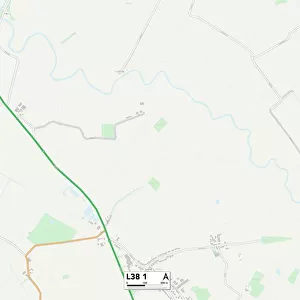
Liverpool L18 1 Map

![]()
Wall Art and Photo Gifts from Map Marketing
Liverpool L18 1 Map
Postcode Sector Map of Liverpool L18 1
Media ID 19972949
Alverstone Road Arlington Avenue Ashdale Road Blenheim Road Bromley Avenue Crawford Avenue Dudley Road Elmbank Road Greenbank Road Hollybank Road Ingleton Road Ivydale Road Kingsdale Road Liverpool Norbury Avenue Oakbank Road Oakdale Road Penny Lane Russell Road Stanton Road Trentham Avenue Welbeck Avenue Zetland Road
FEATURES IN THESE COLLECTIONS
> Europe
> United Kingdom
> England
> London
> Boroughs
> Bromley
> Europe
> United Kingdom
> England
> London
> Boroughs
> Croydon
> Europe
> United Kingdom
> Scotland
> Zetland
> Map Marketing
> Postcode Sector Maps
> L - Liverpool
> Maps and Charts
> Related Images
MADE IN THE USA
Safe Shipping with 30 Day Money Back Guarantee
FREE PERSONALISATION*
We are proud to offer a range of customisation features including Personalised Captions, Color Filters and Picture Zoom Tools
SECURE PAYMENTS
We happily accept a wide range of payment options so you can pay for the things you need in the way that is most convenient for you
* Options may vary by product and licensing agreement. Zoomed Pictures can be adjusted in the Cart.
![Elsie Speicher [verso], 1920. Creator: George Wesley Bellows](/sq/731/elsie-speicher-verso-1920-creator-22171886.jpg.webp)