Home > Europe > United Kingdom > Scotland > Stirlingshire > Stirling
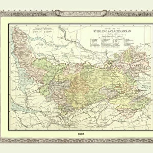
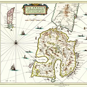
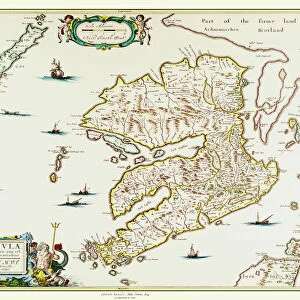
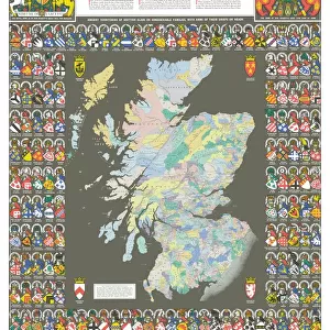
Old County Map of Sterlingshire 1654 by Johan Blaue from the Atlas Novus

![]()
Wall Art and Photo Gifts from MapSeeker
Old County Map of Sterlingshire 1654 by Johan Blaue from the Atlas Novus
This detailed and most attractive reproduction map of Sterlingshire, Scotland, has been carefully art worked from a scan of an antique original. The famous firm of Dutch cartographers and publishers was established in the late 16th century by Willem Janszoon Blaeu in Amsterdam. Blaeu was a maker of globes and scientific instruments and purchased some of his early map plates from Jodocus Hondius. From this small beginning was to emerge one of the largest and most prolific map publishing houses of the seventeenth century
Welcome to the Mapseeker Image library and enter an historic gateway to one of the largest on-line collections of Historic Maps, Nostalgic Views, Vista's and Panorama's from a World gone by.
Media ID 20348019
Blaeu Blaeu Family Blaue Map County Map County Map Of Scotland Historic Map Johan Blaeu Johan Blaeu Map Old Blaue Map Old County Map Old Scottish County Map Scottish County Map Stirling Stirlingshire
FEATURES IN THESE COLLECTIONS
> Arts
> Artists
> B
> Willem Blaeu
> Arts
> Artists
> H
> Jodocus Hondius
> Arts
> Photorealistic artworks
> Detailed art pieces
> Masterful detailing in art
> Europe
> United Kingdom
> Scotland
> Maps
> Europe
> United Kingdom
> Scotland
> Stirling
> Europe
> United Kingdom
> Scotland
> Stirlingshire
> Related Images
> Europe
> United Kingdom
> Scotland
> Stirlingshire
> Stirling
> Maps and Charts
> Early Maps
> Maps and Charts
> Related Images
> Maps and Charts
> Willem Janszoon Blaeu
> MapSeeker
> Maps from the British Isles
> Scotland and Counties PORTFOLIO
EDITORS COMMENTS
This exquisite print showcases an Old County Map of Sterlingshire from 1654, meticulously reproduced from the original by Johan Blaue. The map is a true testament to the artistry and precision of Dutch cartographers and publishers during the 17th century. Johan Blaue, a renowned member of the esteemed Blaeu family, established his firm in Amsterdam in the late 16th century. Initially specializing in globes and scientific instruments, Blaue soon expanded his repertoire to include maps. This particular map of Sterlingshire was crafted with utmost care, ensuring that every detail is faithfully preserved. As you gaze upon this historic masterpiece, you are transported back in time to Scotland's rich past. The intricate lines and delicate shading depict not only geographical features but also provide insight into the region's history and development. Sterlingshire comes alive on this map as its towns, villages, rivers, and mountains are vividly illustrated. It serves as a captivating window into a bygone era when cartography was both an art form and a scientific endeavor. Whether you have ancestral ties to Sterlingshire or simply appreciate historical maps, this print will undoubtedly captivate your imagination. Display it proudly as a tribute to Scotland's heritage or use it as an educational tool for those curious about our world's fascinating past.
MADE IN THE USA
Safe Shipping with 30 Day Money Back Guarantee
FREE PERSONALISATION*
We are proud to offer a range of customisation features including Personalised Captions, Color Filters and Picture Zoom Tools
SECURE PAYMENTS
We happily accept a wide range of payment options so you can pay for the things you need in the way that is most convenient for you
* Options may vary by product and licensing agreement. Zoomed Pictures can be adjusted in the Cart.