Home > Animals > Mammals > Dogs (Wild) > Bush Dog
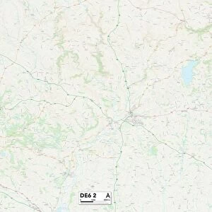
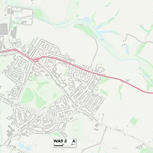
South Derbyshire DE12 8 Map

![]()
Wall Art and Photo Gifts from Map Marketing
South Derbyshire DE12 8 Map
Postcode Sector Map of South Derbyshire DE12 8
Media ID 19969563
Blacksmiths Close Burton Road Chapel Street Church Croft Church Lane Church Street Clifton Road Coal Pit Lane Coopers Close Coton Road Croft Close Dog Lane Elms Road Glebe Close Gorsey Lane Green Lane Hawthorn Avenue Hunts Lane Linton Road Main Street Manor Drive Mill Street Mount Pleasant Lane New Road New Street Oak Tree Close Orchard Close Rectory Lane Riverside Sandy Lane South Derbyshire Stanley Close Station Lane Strawberry Lane The Chase The Glebe The Ropewalk Vicarage Walk Yew Tree Gardens Yew Tree Road Lullington
FEATURES IN THESE COLLECTIONS
> Animals
> Mammals
> Dogs (Wild)
> Bush Dog
> Animals
> Mammals
> Muridae
> Heath Mouse
> Arts
> Portraits
> Pop art gallery
> Street art portraits
> Europe
> United Kingdom
> England
> Derbyshire
> Clifton
> Europe
> United Kingdom
> England
> Derbyshire
> Heath
> Europe
> United Kingdom
> England
> Derbyshire
> Lane End
> Europe
> United Kingdom
> England
> Derbyshire
> Linton
> Europe
> United Kingdom
> England
> Derbyshire
> Lullington
> Europe
> United Kingdom
> England
> Derbyshire
> Mount Pleasant
> Europe
> United Kingdom
> England
> Derbyshire
> New Mills
> Map Marketing
> Postcode Sector Maps
> DE - Derby
MADE IN THE USA
Safe Shipping with 30 Day Money Back Guarantee
FREE PERSONALISATION*
We are proud to offer a range of customisation features including Personalised Captions, Color Filters and Picture Zoom Tools
SECURE PAYMENTS
We happily accept a wide range of payment options so you can pay for the things you need in the way that is most convenient for you
* Options may vary by product and licensing agreement. Zoomed Pictures can be adjusted in the Cart.