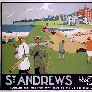
Home > Europe > United Kingdom > Scotland > Fife > St Andrews
Dacorum HP2 5 Map

![]()
Wall Art and Photo Gifts from Map Marketing
Dacorum HP2 5 Map
Postcode Sector Map of Dacorum HP2 5
Media ID 19971367
Andrews Close Apollo Way Bathurst Road Cambrian Way Chapel Street Christchurch Road Church Street Clarendon Close Dacorum Downside East Street Farm Way Fletcher Way Garland Close George Street Glamis Place Hardy Road Heather Way Herbert Street High Street Highfield Highfield Lane Jubilee Close Larchwood Road Laurel Close Malvern Way Manley Road Mendip Way Mountfield Road Mulberry Court Orchard Close Pine Tree Close Queensway Ribblesdale Rutland Gardens Smithfield Springfield Road St Marys Road St Pauls Road Tedder Road The Brackens The Gables The Maltings Towers Road Townsend Wensleydale Westerdale Woodhall Lane Allandale Bohemia Cheviots Chilterns Lonsdale Mercers Pentland Quantocks Solway Teesdale Wheatfield
FEATURES IN THESE COLLECTIONS
> Architecture
> Towers
> Churches
> Arts
> Artists
> H
> Paul Hardy
> Europe
> United Kingdom
> England
> Rutland
> Related Images
> Europe
> United Kingdom
> Scotland
> Fife
> St Andrews
> Map Marketing
> Postcode Sector Maps
> HP - Hemel Hempstead
> Maps and Charts
> Related Images
> Popular Themes
> Laurel & Hardy
> Sport
> Sports Stars
> Paul George
MADE IN THE USA
Safe Shipping with 30 Day Money Back Guarantee
FREE PERSONALISATION*
We are proud to offer a range of customisation features including Personalised Captions, Color Filters and Picture Zoom Tools
SECURE PAYMENTS
We happily accept a wide range of payment options so you can pay for the things you need in the way that is most convenient for you
* Options may vary by product and licensing agreement. Zoomed Pictures can be adjusted in the Cart.