Home > Europe > United Kingdom > Wales > Mid Glamorgan > Bridgend
East Ayrshire KA18 4 Map

![]()
Wall Art and Photo Gifts from Map Marketing
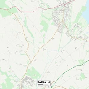
East Ayrshire KA18 4 Map
Postcode Sector Map of East Ayrshire KA18 4
Media ID 19972686
Burnside Castle Place Castlehill East Ayrshire Glebe Street Greenhead Road Greenhill Avenue Hamilton Drive Holm Road Lime Road Mansfield Mansfield Road Mason Avenue West Park Drive Westland Drive
FEATURES IN THESE COLLECTIONS
> Europe
> United Kingdom
> Scotland
> Ayrshire
> Europe
> United Kingdom
> Scotland
> Dumfries and Galloway
> Dumfries
> Europe
> United Kingdom
> Scotland
> Dumfries and Galloway
> Related Images
> Europe
> United Kingdom
> Scotland
> Strathclyde
> Hamilton
> Europe
> United Kingdom
> Scotland
> West Lothian
> Bridgend
> Europe
> United Kingdom
> Wales
> Mid Glamorgan
> Bridgend
> Map Marketing
> Postcode Sector Maps
> KA - Kilmarnock
> Maps and Charts
> Related Images
MADE IN THE USA
Safe Shipping with 30 Day Money Back Guarantee
FREE PERSONALISATION*
We are proud to offer a range of customisation features including Personalised Captions, Color Filters and Picture Zoom Tools
SECURE PAYMENTS
We happily accept a wide range of payment options so you can pay for the things you need in the way that is most convenient for you
* Options may vary by product and licensing agreement. Zoomed Pictures can be adjusted in the Cart.