Home > Europe > United Kingdom > England > Avon
Trafford WA15 0 Map

![]()
Wall Art and Photo Gifts from Map Marketing
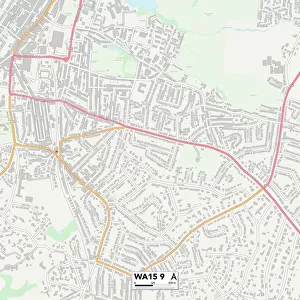
Trafford WA15 0 Map
Postcode Sector Map of Trafford WA15 0
Media ID 19979908
Amberley Drive Ashley Ashley Road Avon Road Back Lane Bankside Barrow Lane Broad Lane Broadway Burnside Buttermere Drive Chapel Drive Chapel Lane Cow Lane Crabtree Avenue Croft Close Greengate Hale Road Haslemere Avenue Hill Top Howard Drive Mill Lane Millway North Road Nursery Avenue Pinfold Close Ridge Avenue Rushey Close Sandown Drive Tanyard Lane The Avenue The Coppice The Copse Trafford Warburton Close Warren Drive Westfields Whitehouse Drive Wilmslow Road Wilton Drive Lynwood
FEATURES IN THESE COLLECTIONS
> Animals
> Farm
> Cattle
> Related Images
> Europe
> United Kingdom
> England
> Avon
> Map Marketing
> Postcode Sector Maps
> WA - Warrington
> Maps and Charts
> Related Images
MADE IN THE USA
Safe Shipping with 30 Day Money Back Guarantee
FREE PERSONALISATION*
We are proud to offer a range of customisation features including Personalised Captions, Color Filters and Picture Zoom Tools
SECURE PAYMENTS
We happily accept a wide range of payment options so you can pay for the things you need in the way that is most convenient for you
* Options may vary by product and licensing agreement. Zoomed Pictures can be adjusted in the Cart.