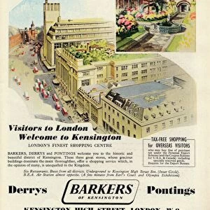
Home > Europe > United Kingdom > England > London > Sights > Kensington Gardens
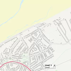
Wirral CH46 9 Map

![]()
Wall Art and Photo Gifts from Map Marketing
Wirral CH46 9 Map
Postcode Sector Map of Wirral CH46 9
Media ID 19968305
Almond Place Avondale Avenue Blackthorn Close Burnley Road Ch46 Cherry Tree Road Gabriel Close Glebelands Road Haig Avenue Holly Place Kensington Gardens Lindale Close Norwich Drive Pine Tree Close Sedgefield Road Spencer Avenue Stuart Avenue Stuart Close Sunningdale Thornfield Close Wheatfield Close Willow Way Wirral Lomond Grove
FEATURES IN THESE COLLECTIONS
> Europe
> United Kingdom
> England
> London
> Sights
> Kensington Gardens
> Map Marketing
> Postcode Sector Maps
> CH - Chester
> Maps and Charts
> Related Images
MADE IN THE USA
Safe Shipping with 30 Day Money Back Guarantee
FREE PERSONALISATION*
We are proud to offer a range of customisation features including Personalised Captions, Color Filters and Picture Zoom Tools
SECURE PAYMENTS
We happily accept a wide range of payment options so you can pay for the things you need in the way that is most convenient for you
* Options may vary by product and licensing agreement. Zoomed Pictures can be adjusted in the Cart.