Home > Europe > United Kingdom > England > London > Towns > Croydon
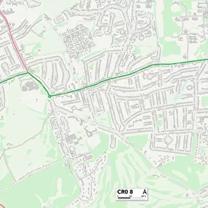
Croydon London UK City Street Map

![]()
Wall Art and Photo Gifts from Fine Art Storehouse
Croydon London UK City Street Map
Vector Illustration of a City Street Map of Croydon, London, UK. Included files are EPS (v10) and Hi-Res JPG.
Data courtesy from Ordnance Survey: VectorMap District
https:/ordnancesurvey.co.uk/business-and-government/products/vectormap-district.html
OS OpenData is free to use under the Open Government Licence (OGL).
Contains OS data eCrown copyright and database right 2017.
http:/nationalarchives.gov.uk/doc/open-government-licence/version/3/
Unleash your creativity and transform your space into a visual masterpiece!
Frank Ramspott
Media ID 15054907
© Frank Ramspott, all rights reserved
Aerial View Computer Graphic Croydon Directly Above Gray Green London Road Map Street Map Text Digitally Generated Image
FEATURES IN THESE COLLECTIONS
> Aerial Photography
> Related Images
> Arts
> Contemporary art
> Digital artwork
> Street art
> Arts
> Portraits
> Pop art gallery
> Street art portraits
> Arts
> Street art graffiti
> Digital art
> Digital paintings
> Arts
> Street art graffiti
> Digital art
> Vector illustrations
> Europe
> United Kingdom
> England
> London
> Boroughs
> Croydon
> Europe
> United Kingdom
> England
> London
> Towns
> Croydon
> Europe
> United Kingdom
> Maps
> Fine Art Storehouse
> Map
> Street Maps
> Maps and Charts
> Related Images
EDITORS COMMENTS
This print showcases a detailed and intricate city street map of Croydon, London, UK. The vector illustration captures the essence of this bustling urban landscape with its network of roads, buildings, and streets. Created by Frank Ramspott, this digitally generated image is a testament to his exceptional cartography skills. The inclusion of EPS (v10) and Hi-Res JPG files allows for versatile usage options. This masterpiece owes its accuracy to the data courtesy from Ordnance Survey: VectorMap District. It's worth noting that OS OpenData is freely available under the Open Government Licence (OGL), offering an opportunity for creative exploration. The color palette used in this design beautifully blends shades of gray, green, blue, and white. The aerial view perspective provides a unique vantage point directly above the cityscape while omitting any human presence. Whether you're an avid collector or simply appreciate fine art prints that celebrate physical geography through computer graphics, this piece will undoubtedly captivate your imagination. Its meticulous attention to detail makes it an ideal addition to any home or office space.
MADE IN THE USA
Safe Shipping with 30 Day Money Back Guarantee
FREE PERSONALISATION*
We are proud to offer a range of customisation features including Personalised Captions, Color Filters and Picture Zoom Tools
SECURE PAYMENTS
We happily accept a wide range of payment options so you can pay for the things you need in the way that is most convenient for you
* Options may vary by product and licensing agreement. Zoomed Pictures can be adjusted in the Cart.