Home > Arts > Artists > H > Jodocus Hondius
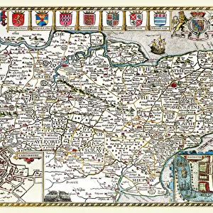
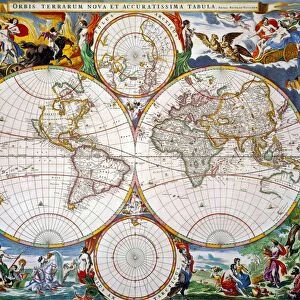
Old County Map of Derbyshire 1648 by Johan Blaeu from the Atlas Novus

![]()
Wall Art and Photo Gifts from MapSeeker
Old County Map of Derbyshire 1648 by Johan Blaeu from the Atlas Novus
This detailed and most attractive reproduction map of Derbyshire has been carefully art worked from a scan of an antique original. The famous firm of Dutch cartographers and publishers was established in the late 16th century by Willem Janszoon Blaeu in Amsterdam. Blaeu was a maker of globes and scientific instruments and purchased some of his early map plates from Jodocus Hondius. From this small beginning was to emerge one of the largest and most prolific map publishing houses of the seventeenth century
Welcome to the Mapseeker Image library and enter an historic gateway to one of the largest on-line collections of Historic Maps, Nostalgic Views, Vista's and Panorama's from a World gone by.
Media ID 20347846
Blaeu Blaeu Family Blaue Map County Map County Map Of England English County Map Historic Map Johan Blaeu Johan Blaeu Map Old Blaue Map Old County Map Old English County Map Derbyshire
FEATURES IN THESE COLLECTIONS
> Arts
> Artists
> B
> Willem Blaeu
> Arts
> Artists
> H
> Jodocus Hondius
> Arts
> Photorealistic artworks
> Detailed art pieces
> Masterful detailing in art
> Europe
> United Kingdom
> England
> Derbyshire
> Related Images
> Europe
> United Kingdom
> England
> Maps
> Maps and Charts
> Early Maps
> Maps and Charts
> Related Images
> Maps and Charts
> Willem Janszoon Blaeu
> MapSeeker
> Maps from the British Isles
> England and Counties PORTFOLIO
EDITORS COMMENTS
This exquisite print showcases the "Old County Map of Derbyshire 1648" by Johan Blaeu, a renowned Dutch cartographer and publisher. Carefully reproduced from an antique original, this detailed map offers a captivating glimpse into the historical geography of Derbyshire. The Blaeu family's cartography legacy began in Amsterdam during the late 16th century when Willem Janszoon Blaeu established his firm. Initially specializing in globes and scientific instruments, Blaeu later acquired map plates from Jodocus Hondius to expand his collection. This marked the humble beginnings of what would become one of the most prolific map publishing houses of the seventeenth century. The craftsmanship evident in this reproduction is truly remarkable. Every intricate detail has been faithfully art worked from a scan of the original antique map, ensuring its authenticity and historical accuracy. As you explore this old English county map, you'll be transported back to 1648, immersing yourself in Derbyshire's rich heritage. Whether you're an avid history enthusiast or simply appreciate fine artistry, this historic Derbyshire map is sure to captivate your imagination. Discover ancient towns and villages nestled amidst rolling hills and meandering rivers as you trace your finger along each carefully drawn contour. Perfect for display or study purposes, this print allows you to admire Johan Blaeu's masterful cartographic skills while adding a touch of timeless elegance to any space. Immerse yourself in history with this stunning piece – a testament to both
MADE IN THE USA
Safe Shipping with 30 Day Money Back Guarantee
FREE PERSONALISATION*
We are proud to offer a range of customisation features including Personalised Captions, Color Filters and Picture Zoom Tools
SECURE PAYMENTS
We happily accept a wide range of payment options so you can pay for the things you need in the way that is most convenient for you
* Options may vary by product and licensing agreement. Zoomed Pictures can be adjusted in the Cart.