Home > Animals > Birds > Passerines > Finches > Atlantic Canary
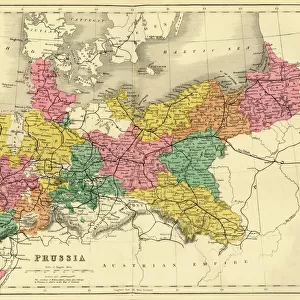
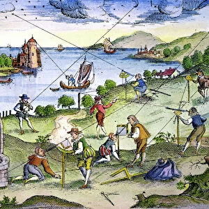
Map of Fuerteventura, Canary Islands

![]()
Wall Art and Photo Gifts from Mary Evans Picture Library
Map of Fuerteventura, Canary Islands
Map of Fuerteventura, Canary Islands, with soundings in fathoms. Date: 1835
Mary Evans Picture Library makes available wonderful images created for people to enjoy over the centuries
Media ID 14262779
© Mary Evans / Pharcide
1830s 1835 Atlantic Canaries Canary Chart Charts Maps Navigation Soundings Fathoms Fuerteventura
FEATURES IN THESE COLLECTIONS
> Animals
> Birds
> Passerines
> Finches
> Atlantic Canary
> Animals
> Mammals
> Muridae
> Water Mouse
> Arts
> Artists
> O
> Oceanic Oceanic
> Europe
> France
> Canton
> Landes
> Maps and Charts
> Related Images
EDITORS COMMENTS
This stunning antique map print from the year 1835 depicts the island of Fuerteventura, located in the Atlantic Ocean and part of the Canary Islands. The intricate detailing showcases the coastline, with its rocky cliffs, sandy beaches, and sheltered bays. The map also includes soundings in fathoms, providing valuable information for mariners navigating the waters surrounding the island during the 1830s. The Canary Islands, a Spanish archipelago, are renowned for their volcanic origin and tropical climate. Fuerteventura, the second largest of the islands, is known for its beautiful beaches, crystal-clear waters, and rugged terrain. This map offers a fascinating glimpse into the cartographic knowledge of the time, providing insight into the exploration and discovery of this island. The map's intricate design showcases the meticulous work of the cartographers and mapmakers of the era. The Atlantic Ocean, surrounding the island, is depicted with its depths and underwater features carefully charted. The landmasses, both on Fuerteventura and neighboring islands, are delineated with impressive accuracy, revealing the vast expanse of water and land that make up this unique corner of the world. This map print is an essential addition to any collection of historical maps, maritime charts, or those with an interest in the Canary Islands, the Atlantic Ocean, or the history of cartography. Its antique charm and intricate detailing make it a captivating piece of art and a testament to the remarkable cartographic achievements of the past.
MADE IN THE USA
Safe Shipping with 30 Day Money Back Guarantee
FREE PERSONALISATION*
We are proud to offer a range of customisation features including Personalised Captions, Color Filters and Picture Zoom Tools
SECURE PAYMENTS
We happily accept a wide range of payment options so you can pay for the things you need in the way that is most convenient for you
* Options may vary by product and licensing agreement. Zoomed Pictures can be adjusted in the Cart.