Home > Arts > Artists > C > Edward Curtis
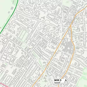
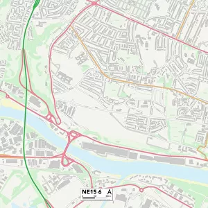
Manchester M19 3 Map

![]()
Wall Art and Photo Gifts from Map Marketing
Manchester M19 3 Map
Postcode Sector Map of Manchester M19 3
Media ID 19975789
Agnes Street Aitken Street Alexandra Terrace Anchor Close Audley Road Back Chapel Street Barlow Road Belvoir Avenue Bristol Avenue Broom Avenue Broom Lane Chapel Street Charlton Road Cleveland Avenue Curtis Road Delamere Road Dorset Road Garfield Avenue Gloucester Avenue Gordon Avenue Greenway Avenue Greystoke Avenue Guildford Road Highfield Road Hornbeam Road Kettering Road King Edward Street Langdale Avenue Langland Close Lincoln Avenue Lonsdale Road Manchester Manor Road Marley Road Mercer Street Molyneux Road Mullion Close Pullman Close Ratcliffe Street Samuel Street Southwold Close St Marks Street Stanhope Street The Crescent Westminster Street Whalley Avenue Yew Tree Avenue York Street Farm Yard
FEATURES IN THESE COLLECTIONS
> Arts
> Artists
> C
> Edward Curtis
> Arts
> Artists
> K
> Samuel King
> Arts
> Artists
> L
> Samuel Lane
> Europe
> United Kingdom
> England
> Bristol
> Bristol
> Europe
> United Kingdom
> England
> Cleveland
> Europe
> United Kingdom
> England
> Dorset
> Grove
> Europe
> United Kingdom
> England
> Dorset
> Related Images
> Europe
> United Kingdom
> England
> Manchester
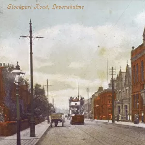
> Levenshulme
> Europe
> United Kingdom
> England
> Manchester
> Manchester
> Europe
> United Kingdom
> England
> Manchester
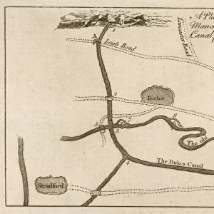
> Worsley
> Map Marketing
> Postcode Sector Maps
> M - Manchester
MADE IN THE USA
Safe Shipping with 30 Day Money Back Guarantee
FREE PERSONALISATION*
We are proud to offer a range of customisation features including Personalised Captions, Color Filters and Picture Zoom Tools
SECURE PAYMENTS
We happily accept a wide range of payment options so you can pay for the things you need in the way that is most convenient for you
* Options may vary by product and licensing agreement. Zoomed Pictures can be adjusted in the Cart.