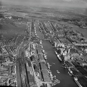
Home > Europe > United Kingdom > England > London > Boroughs > Newham
Newcastle NE13 7 Map

![]()
Wall Art and Photo Gifts from Map Marketing
Newcastle NE13 7 Map
Postcode Sector Map of Newcastle NE13 7
Media ID 19974664
Arundel Close Ash Avenue Augusta Close Beacon Drive Beech Avenue Bracken Close Brookside Avenue Castle Street Charles Street Church Close Coach Lane Dene Avenue Edwin Street Elm Avenue Farndale Close Front Street George Street Glen Drive Grey Street Hall Drive Hawthorn Avenue High Ridge Highfield Place Holmes Close Launceston Close Link Road Main Road Mason Street Mayfield Place Newcastle Nicholson Close North View Oak Avenue Pine Avenue Poplar Avenue Priory Place Sandy Lane Seaton Place Sycamore Avenue The Crest Thorn Close Westfield Avenue Dinnington
FEATURES IN THESE COLLECTIONS
> Europe
> United Kingdom
> England
> Herefordshire
> Maps
> Europe
> United Kingdom
> England
> London
> Boroughs
> Newham
> Europe
> United Kingdom
> England
> London
> Politics
> Charles Grey
> Europe
> United Kingdom
> Northern Ireland
> County Down
> Newcastle
> Europe
> United Kingdom
> Scotland
> Aberdeenshire
> Aberdeen
> Europe
> United Kingdom
> Scotland
> Strathclyde
> Prestwick
> Map Marketing
> Postcode Sector Maps
> NE - Newcastle upon Tyne
> Maps and Charts
> Related Images
MADE IN THE USA
Safe Shipping with 30 Day Money Back Guarantee
FREE PERSONALISATION*
We are proud to offer a range of customisation features including Personalised Captions, Color Filters and Picture Zoom Tools
SECURE PAYMENTS
We happily accept a wide range of payment options so you can pay for the things you need in the way that is most convenient for you
* Options may vary by product and licensing agreement. Zoomed Pictures can be adjusted in the Cart.