Home > Europe > United Kingdom > England > London > Boroughs > Ealing
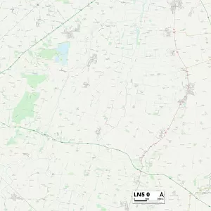
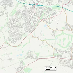
Kirklees WF17 8 Map

![]()
Wall Art and Photo Gifts from Map Marketing
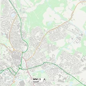
Kirklees WF17 8 Map
Postcode Sector Map of Kirklees WF17 8
Media ID 19980780
Anne Street Belle Vue Street Bradford Road Cemetery Road Centenary Way Charnwood Close Coal Pit Lane Common Road Crowther Street Dale Lane Denham Street Diamond Street Emerald Street Enfield Close Fairfield Drive Fairview Avenue Fairview Crescent Fairview Road Greenfield View Hampson Street Healey Close Ings Road Kirklees Laurel Drive Laurel Grove Lea Road Lonsdale Avenue Melton Street Mortimer Avenue Mortimer Street Mount Avenue North Street Oakhill Road Pearl Street Plover Drive Richmond Road Ruby Street South Bank Road The Avenue The Burrows The Covert The Drive The Grove Thomas Street Upton Street Victoria Street Welwyn Avenue Healey Magnolias
FEATURES IN THESE COLLECTIONS
> Animals
> Birds
> Apodiformes
> Hummingbirds
> Garden Emerald
> Arts
> Artists
> C
> Thomas Cross
> Arts
> Artists
> H
> Thomas Horner
> Arts
> Artists
> N
> Thomas North
> Europe
> United Kingdom
> England
> London
> Boroughs
> Ealing
> Europe
> United Kingdom
> England
> London
> Boroughs
> Enfield
> Map Marketing
> Postcode Sector Maps
> WF - Wakefield
> Maps and Charts
> Related Images
MADE IN THE USA
Safe Shipping with 30 Day Money Back Guarantee
FREE PERSONALISATION*
We are proud to offer a range of customisation features including Personalised Captions, Color Filters and Picture Zoom Tools
SECURE PAYMENTS
We happily accept a wide range of payment options so you can pay for the things you need in the way that is most convenient for you
* Options may vary by product and licensing agreement. Zoomed Pictures can be adjusted in the Cart.