Home > Arts > Artists > T > John Tallis
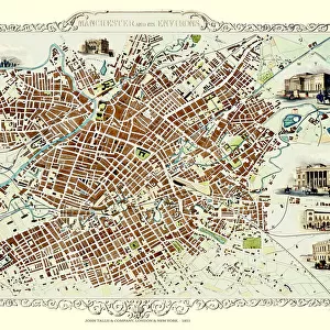
Old Map of Belfast 1851 by John Tallis

![]()
Wall Art and Photo Gifts from MapSeeker
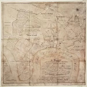
Old Map of Belfast 1851 by John Tallis
The River Lagan dominates the west side of this John Tallis 1851 plan of Belfast with Queens Bridge crossing into the town of Belfast in Northern Ireland. There are six splendid illustrations. These are of Queens College, Ulster Institution for the deaf, dumb and blind, Ulster Railway Station, Ballast Office, and a view across Queens Bridge to Belfast and the Court House
Welcome to the Mapseeker Image library and enter an historic gateway to one of the largest on-line collections of Historic Maps, Nostalgic Views, Vista's and Panorama's from a World gone by.
Media ID 20347878
Historic Map John Tallis John Tallis Map Old Town Plan Tallis Map Belfast Belfast City
FEATURES IN THESE COLLECTIONS
> Arts
> Artists
> T
> John Tallis
> Europe
> Republic of Ireland
> Maps
> Europe
> United Kingdom
> Northern Ireland
> Belfast
> Europe
> United Kingdom
> Northern Ireland
> Maps
> Europe
> United Kingdom
> Northern Ireland
> Posters
> Europe
> United Kingdom
> Northern Ireland
> Railways
> Europe
> United Kingdom
> Northern Ireland
> Related Images
> Europe
> United Kingdom
> Northern Ireland
> Rivers
> Maps and Charts
> Related Images
> MapSeeker
> British Town And City Plans
> Irish PORTFOLIO
EDITORS COMMENTS
This print showcases an exquisite piece of history - the Old Map of Belfast from 1851 by John Tallis. As we delve into this remarkable town plan, our eyes are immediately drawn to the majestic River Lagan that gracefully dominates the west side of Belfast. The iconic Queens Bridge elegantly connects us to the bustling town, inviting us to explore its rich heritage. Within this meticulously detailed map, six splendid illustrations catch our attention and transport us back in time. We glimpse Queens College, a beacon of knowledge and enlightenment for generations past. Nearby stands the Ulster Institution for the deaf, dumb, and blind, a testament to society's compassion towards those with disabilities. Further along our journey through this historic map lies Ulster Railway Station - a hub of activity where countless travelers embarked on adventures near and far. The Ballast Office reminds us of Belfast's maritime significance as it oversaw vital operations related to shipping and trade. Finally, our gaze settles upon a breathtaking view across Queens Bridge towards Belfast itself. In this panorama lies the magnificent Court House - an architectural gem that symbolizes justice within these vibrant streets. As we admire this old map of Belfast by John Tallis, we cannot help but feel connected to its storied past. It serves as a reminder that beneath modernity's veneer lies a city steeped in history and brimming with tales waiting to be discovered anew.
MADE IN THE USA
Safe Shipping with 30 Day Money Back Guarantee
FREE PERSONALISATION*
We are proud to offer a range of customisation features including Personalised Captions, Color Filters and Picture Zoom Tools
SECURE PAYMENTS
We happily accept a wide range of payment options so you can pay for the things you need in the way that is most convenient for you
* Options may vary by product and licensing agreement. Zoomed Pictures can be adjusted in the Cart.