Home > Europe > United Kingdom > England > London > Boroughs > Hillingdon
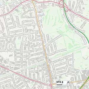
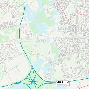
Hillingdon UB7 9 Map

![]()
Wall Art and Photo Gifts from Map Marketing
Hillingdon UB7 9 Map
Postcode Sector Map of Hillingdon UB7 9
Media ID 19980140
Almond Avenue Beech Close Blackthorn Avenue Blossom Way Briar Way Byron Way Chapman Close Cherry Lane Coleridge Way Dell Road East Road Eastwood Road Edison Close Evergreen Drive Fir Tree Avenue Foxglove Close Hanson Close Hawthorne Crescent Hazel Avenue Hillingdon Holly Gardens Keats Way Kings Road Kingston Lane Maxwell Road Milton Way Mulberry Crescent Myrtle Close Napier Close North Road Oak Avenue Poppy Close Queens Road Scott Close South Close South Road Station Road The Glebe Thornton Avenue Thornton Close Vine Close Walnut Avenue Warwick Road West Road Wordsworth Way
FEATURES IN THESE COLLECTIONS
> Europe
> United Kingdom
> England
> London
> Boroughs
> Hillingdon
> Map Marketing
> Postcode Sector Maps
> UB - Uxbridge
> Maps and Charts
> Related Images
MADE IN THE USA
Safe Shipping with 30 Day Money Back Guarantee
FREE PERSONALISATION*
We are proud to offer a range of customisation features including Personalised Captions, Color Filters and Picture Zoom Tools
SECURE PAYMENTS
We happily accept a wide range of payment options so you can pay for the things you need in the way that is most convenient for you
* Options may vary by product and licensing agreement. Zoomed Pictures can be adjusted in the Cart.