Home > Europe > United Kingdom > England > London > Transport > Railway
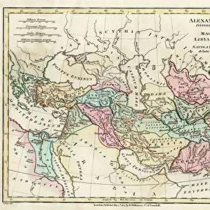
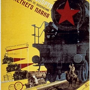
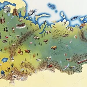
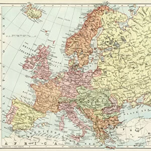
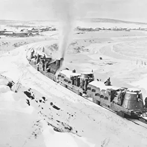
Map of the railway network in the European part of the Soviet Union, 1930s (litho)
")
![]()
Wall Art and Photo Gifts from Fine Art Finder
Map of the railway network in the European part of the Soviet Union, 1930s (litho)
6014778 Map of the railway network in the European part of the Soviet Union, 1930s (litho) by English School, (20th century); Private Collection; (add.info.: Map of the railway network in the European part of the Soviet Union, 1930s. Illustration from Railway Wonders of the World (The Amalgamated Press Limited, London, c1937).); © Look and Learn
Media ID 22812864
© Look and Learn / Bridgeman Images
Lines Network Soviet Union Ussr 1930 1939 Years 30 30s 1930 1939 Years 30s 19301939 1933 34
FEATURES IN THESE COLLECTIONS
> Asia
> Related Images
> Europe
> Related Images
> Europe
> Russia
> Related Images
> Europe
> United Kingdom
> England
> London
> Transport
> Railway
> Fine Art Finder
> Artists
> English School
> Fine Art Finder
> Artists
> French School
> Maps and Charts
> Early Maps
> Maps and Charts
> Related Images
EDITORS COMMENTS
This lithograph print showcases a detailed "Map of the railway network in the European part of the Soviet Union" during the 1930s. Created by an English School artist, this historical piece offers a fascinating glimpse into the transport and travel infrastructure of that era. The map, originally featured in Railway Wonders of the World, provides a comprehensive overview of the extensive rail lines crisscrossing through Russia and Asia. The intricate illustration highlights not only the vastness of this railway network but also its significance in connecting different regions within Europe and beyond. As we delve into this snapshot from history, we are transported back to a time when railways played a crucial role in shaping economic development, cultural exchange, and political alliances. The litho's muted color palette adds to its vintage charm while allowing us to focus on tracing each line as it winds through cities, towns, and remote landscapes. It serves as a visual testament to human ingenuity and engineering prowess during an era marked by rapid industrialization. As we explore this remarkable artwork further, let us appreciate how these railways served as lifelines for countless individuals - facilitating trade between nations and fostering connections among diverse communities across borders. This print is not just an artistic representation; it encapsulates an important chapter in history that continues to resonate with our fascination for exploration and progress.
MADE IN THE USA
Safe Shipping with 30 Day Money Back Guarantee
FREE PERSONALISATION*
We are proud to offer a range of customisation features including Personalised Captions, Color Filters and Picture Zoom Tools
SECURE PAYMENTS
We happily accept a wide range of payment options so you can pay for the things you need in the way that is most convenient for you
* Options may vary by product and licensing agreement. Zoomed Pictures can be adjusted in the Cart.