Home > Europe > United Kingdom > England > London > Boroughs > Bromley
Bromley BR2 9 Map

![]()
Wall Art and Photo Gifts from Map Marketing
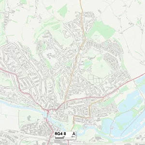
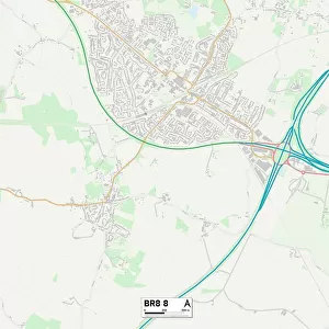
Bromley BR2 9 Map
Postcode Sector Map of Bromley BR2 9
Media ID 19965890
Addison Road Albert Road Appledore Close Balfour Road Bloomfield Road Bourne Road Bromley Brooklyn Road Cameron Road Carisbrooke Road Chantry Lane Cheriton Avenue Cowper Close Cowper Road Cromwell Avenue Cromwell Close Crown Lane Elliott Road Glanville Road Godwin Road Havelock Road Hayes Lane Hayes Road Haywood Road Herbert Road Heron Court Johnson Road Langdon Road Lavender Close Marlborough Road Mead Way Napier Road Nelson Road Newton Terrace Oakwood Avenue Peartree Close Pinewood Road Prospect Place Raglan Road Sandford Road Southlands Road St Marks Road Stanley Road Streamside Close Union Road Victoria Road Vincent Close Walpole Road Waverley Close Wellington Road Wendover Road Whitehall Road Wolfe Close Devonshire Square
FEATURES IN THESE COLLECTIONS
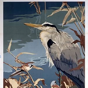
> Animals
> Birds
> Herons
> Green Heron
> Animals
> Birds
> Herons
> Related Images
> Animals
> Mammals
> Cats (Wild)
> Tiger
> Arts
> Artists
> F
> Newton Fielding
> Europe
> United Kingdom
> England
> London
> Boroughs
> Bromley
> Europe
> United Kingdom
> England
> London
> Sights
> Victoria Park
> Map Marketing
> Postcode Sector Maps
> BR - Bromley
> Maps and Charts
> Related Images
MADE IN THE USA
Safe Shipping with 30 Day Money Back Guarantee
FREE PERSONALISATION*
We are proud to offer a range of customisation features including Personalised Captions, Color Filters and Picture Zoom Tools
SECURE PAYMENTS
We happily accept a wide range of payment options so you can pay for the things you need in the way that is most convenient for you
* Options may vary by product and licensing agreement. Zoomed Pictures can be adjusted in the Cart.